Milton - Map of Parks & Diamonds
Updated November 28, 2015Milton is a town west of Mississauga, part of the Halton Region in the Greater Toronto Area.
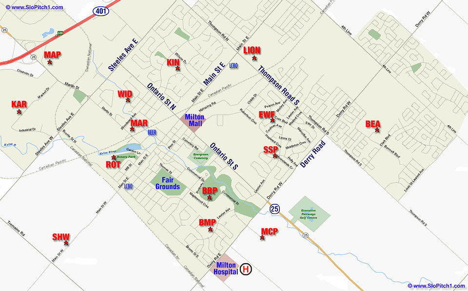
See below for a complete list of parks and directions. Most diamonds on the map are clickable for detailed map and directions.


Milton - List of Parks & Diamonds
| Park Name | Abbr | Address/Location | City/Area |
|---|---|---|---|
| Baldwin Park | KIN | See Kinsmen Park, 180 Wilson Drive, Milton, ON L9T 3J9,
west side, south off Steeles Avenue, east of Ontario Street (Hwy 25); Class B unfenced diamond. | Milton |
| Beaty Park | BEA | Beaty Neighbourhood Park North, McDowell Crescent, Milton, ON L9T 6R4; fenced diamond. | Milton |
| Brian Best Park | BBP | 395 Williams Avenue, Milton, ON L9T 2G4, north-west corner at Commercial Street, two blocks north of Derry Road; one block west of Ontario Street (Hwy 25); two fenced diamonds. | Milton |
|
Bronte
Meadows Park | BMP | 165 Laurier Avenue, Milton, ON L9T 3R5,
north side, east off Bronte Road, north of Derry Road; fenced diamond. | Milton |
| Brookville Park | BRK | 1325 Guelph Line, Campbellville, ON L0P 1B0,
east side, north of 15 Sideroad; 2 lit fenced diamonds (not on map). | Milton |
| Campbellville Park - Old | CP-O | 105 Campbell Avenue East, Campbellville, ON L0P 1B0,
at Wheelihan Way, east off Guelph Line, south of Hwy 401; fenced diamond. | Campbellville |
| Campbellville Park - New | CP-N | 2686 Reid Side Road, Campbellville, ON,
south side, west off Guelph Line, south of Hwy 401; fenced diamond. | Campbellville |
| Drumquin Park | DRUM | 185 Britannia Road, Milton, ON L9T 7G6,
north side; just west of Trafalgar Road; 2 lit fenced diamonds. | Drumquin |
| E. W. Foster School | EWF | Behind E W Foster School, 320 Coxe Blvd, Milton, ON L9T 4M5, west side, between Childs Drive & Laurier Ave, west off Thompson Road, south of Main St; Class B unfenced diamond. | Milton |
|
Karmax
Diamond | KAR | At Karmax Heavy Stamping, 333 Market Drive, Milton, ON L9T 4Z7,
north side, west off Martin Street, south of Hwy 401, north of Steeles Ave; unfenced diamond. | Milton |
| Kinsmen Park | KIN | Beside Robert Baldwin Public School, 180 Wilson Drive, Milton, ON L9T 3J9,
west side, south off Steeles Avenue, east of Ontario Street (Hwy 25); Class B unfenced diamond. | Milton |
|
Lions
Sports Park | LION | Lions Sports Park, 77 Thompson Road, Milton, ON L9T 6B5,
east side, south of Milton Memorial Arena, south of Main Street; 3 lit fenced diamonds. | Milton |
|
Martin Street
Park | MAR | 266 Woodward Avenue, Milton, ON L9T 1V2, at Martin Street; Class B unfenced diamond. | Milton |
|
Maplehurst
Park | MAP | 661 Martin Street, Milton, ON L9T 3V9,
at Maplehurst Correctional Complex,
Hwy 25, east side, just south of Hwy 401; lit fenced diamond. | Milton |
|
Milton
Community Park | MCP | 805 Santa Maria Blvd, Milton, ON L9T 6W2, end of Santa Maria Blvd, south off Derry Road, one block west of Hwy 25; 2 premier lit fenced hardball diamonds. | Milton |
| Omagh Park | OMA | 9850 Britannia Road, Milton, ON L9T 7E8,
south side; west of 4th Line, behind Omagh Church Of Christ; lit fenced diamond. | Milton |
| Rotary Park | ROT | 100 Garden Lane, Milton, ON L9T 1S2, end of Garden Lane, north off Mill St, east of Bronte St, north of Main St; 1 B class diamond and 2 T-ball diamonds. | Milton |
| Sam Sherratt Park | SSP | Behind Sam Sherratt Public School, 649 Laurier Avenue, Milton, ON L9T 4N4, north side, between Ontario Street and Thompson Road, one block north of Derry Road; 1 softball and 2 T-ball diamonds. | Milton |
|
Sherwood
District Park | SHW | 6125 Main Street West, Milton, ON L9T 2Y1,
west of Bronte Road; lit fenced diamond. | Milton |
|
W I Dick
Middle School | WID | W I Dick Middle School, 351 Highside Drive, Milton, ON L9T 1W8,
north side, west of Ontario Street, north of Woodward, south of Steeles; B class diamond. | Milton |
| Milton District Hospital | H | Milton District Hospital, 7030 Derry Road, Milton, ON L9T 7H6
south-east corner of Derry Road and Bronte Street South. | Milton |
| Beer Store | BEER | Beer Store, 1071 Maple Ave, Milton, ON L9T 0A5 (not on map) -
map
Beer Store, 51 Millside Drive, Milton, ON L9T 1S8 - map | Milton |
| LCBO | LCBO | LCBO, 14 Main Street East, Milton, ON L9T 1N3 (at Bronte Road) -
map
LCBO, 830 Main Street East, Milton, ON L9T 0J4 (west of Thompson Rd)- map | Milton |

Maps to GTA Parks and Diamonds
Updated November 1, 2018


SloPitch1.com Home - RSPA Home - Site Map
For more information about SloPitch1.com
please contact: Randy Warren
e-mail: accent@slopitch1.com
RSPA 2025 Slo-Pitch Tournaments
All tournaments tentatively Saturday one-day.Saturday, May 3 • June 14 • July 12
• August 16 • September 20 • September 27

